
With deadly Texas flooding dominating headlines this weekend, we now shift focus to Tropical Storm Chantal, which made landfall near Myrtle Beach, South Carolina, early Sunday. This marks the first tropical storm to make landfall in the 2025 Atlantic hurricane season—and the earliest to do so since 2022.
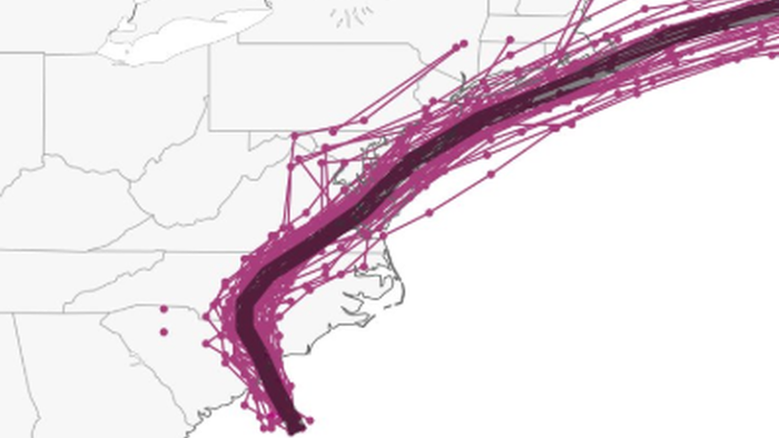
Chantal is the third tropical storm of this year’s hurricane season, following Andrea and Barry, both of which formed in June. The new storm appeared on our radar Friday, with spaghetti models showing a potential path up the U.S. East Coast, through parts of the Mid-Atlantic, and possibly over southern New Jersey and New York City.
Updated spaghetti models posted by meteorologist Ben Noll on X show a strong level of confidence in Chantal’s track into the Mid-Atlantic and Northeast, where severe weather could be seen next from D.C. to New York and Boston.
Tropical Storm Chantal made landfall in South Carolina early Sunday, the earliest U.S. landfall since 2022.
Chantal will drag deep tropical moisture across North Carolina on Sunday and the Mid-Atlantic and Northeast on Monday and Tuesday, bringing a risk for flash-flooding. pic.twitter.com/q5ASjIJR2r
— Ben Noll (@BenNollWeather) July 6, 2025
“In addition to being the first of this season, Chantal’s landfall was the earliest in the season since 2022 in the United States,” Knoll noted in a weather post featured in the Washignton Post.
Copious amounts of tropical moisture from Chantal will stream into the Mid-Atlantic and Northeast on Monday — with precipitable water values of 2 to 3 inches — bringing drenching downpours.
There could be some sneaky flash flooding. pic.twitter.com/qsyAWP6k3F
— Ben Noll (@BenNollWeather) July 6, 2025
Additional forecast models show a high level of confidence that Chantal will track up the East Coast before spinning out into the Atlantic. Models are subject to change.

The months of August and September tend to be the most active for hurricane activity.

If you have travel plans along the East Coast this week, keep a close eye on Chantal.
Loading…


