Ahead of next week’s return to global warming, thank you, Al Gore, for listening to our prayers in the Mid-Atlantic and Northeast after weeks of below-average temperatures that felt like the Arctic. A weekend snowstorm is set to blanket the region with accumulating snow.
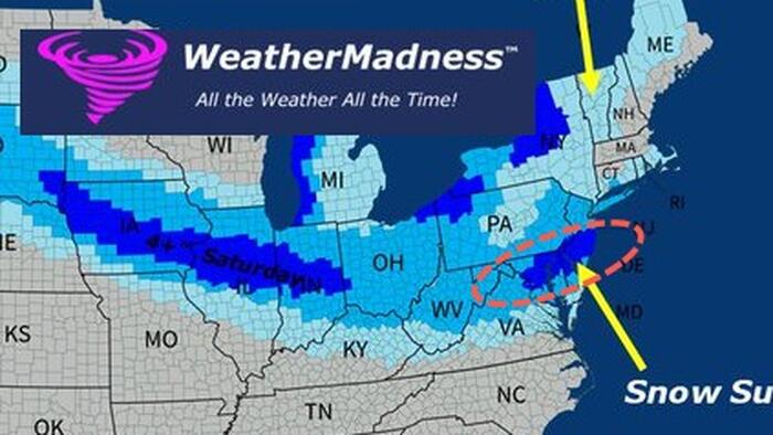
The NWS Weather Prediction Center published a new snowfall forecast for a weekend winter storm that stretches from the northern High Plains of Montana through the Ohio Valley, the central Appalachians, and the Northeast, including major cities from Washington, D.C., to Baltimore, Philadelphia, New York City, and Boston.

Private weather forecaster Weather Madness noted on X, “I expect an Arctic low to develop along the Arctic front, which could produce extra snow along the I-95 corridor from NYC to DCA.”
Weather Madness expects parts of the Mid-Atlantic to receive 4 to 8 inches.

Meteorologist Steven DiMartino at NY NJ PA Weather published a short video earlier that details the incoming snow threat for the Mid-Atlantic area.
Snowfall On The Way!
A premium public discussion focused on the snow threat for Sunday morning. pic.twitter.com/OtGWW5Mr37
— NY NJ PA Weather (@nynjpaweather) December 12, 2025
More from meteorologist Rayn Maue…
Mother Nature will take out her paint brush and color in the Northeast along the coast including NYC and Boston with “blue coloring” or more than 2″ of snowfall ❄️and then just about everyone will have had snow before December 15th.
That’s a successful pre-winter! pic.twitter.com/A8cKE8Qjej
— Ryan Maue (@RyanMaue) December 12, 2025
On Thursday, we noted in “After Polar Vortex US Freeze, Global Warming Returns Before Christmas” that a warm-up for the eastern half of the US is expected to begin on Tuesday-Wednesday of next week.

Related:
Meteorologist Ben Noll said, “A whopping 235 million people across the United States have experienced well below-average temperatures so far this December.”
Next week, much milder air from the West will erase the chill in the East.
There are signs these warmer conditions may stick around leading up to Christmas. pic.twitter.com/0AlWkQYWvp
— Ben Noll (@BenNollWeather) December 12, 2025
We’ll take the warmth. Thanks, Al Gore. However, January is right around the corner.
Loading recommendations…